Title:
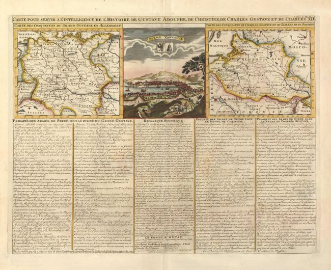
“Carte pour servir a l'Intelligence de l'Histoire de Gustave Adolphe, de Christine, de Charles Gustave et de Charles XII”
Map Maker:
Henry Abraham Chatelain
This folio sheet has a view of Berga Norway flanke... (full text available to subscribers)
| Item Detail |
| |
| |
MapMaker: |
Henry Abraham Chatelain
|
|
| |
| |
Subject: |
Central and Northeastern Europe |
|
| |
Period/Size: |
1714 / 13.7" x 17.5" (34.8 x 44.5 cm)
|
|
| |
Color: |
Colored
|
|
| |
Condition: |
(A) Sharp impression and attractive color. There is some faint toning in the text, and an old paper repair on the lower centerfold. The maps and view are not affected. (condition help) |
|
| |
Source: |
Atlas Historique |
|
| |
References: |
|
|
| |
|
|
| Sales Information |
| |
| |
Price: |
|
|
| |
| |
Offered by: |
Old World Auctions |
|
| |
Catalog: |
Auction No. 131 - Antique Maps, Charts, Atlases & Globes (682) |
|
| |
Lot/Item #: |
617 |
|
| |
| |
Date: |
02/2010
|
|
| |
| |
|
Antique Maps - Valuation and Pricing, Descriptions, Resources |
|
Home |
Information |
Search |
Register |
Contact Us |
Site Map
Americana Exchange, Inc. © 1999 - 2024 Americana Exchange, Inc.. All rights reserved.
OldMaps.com, the OldMaps.com logo and
AMPR are service marks or registered service marks of Americana Exchange, Inc..
|