Title:
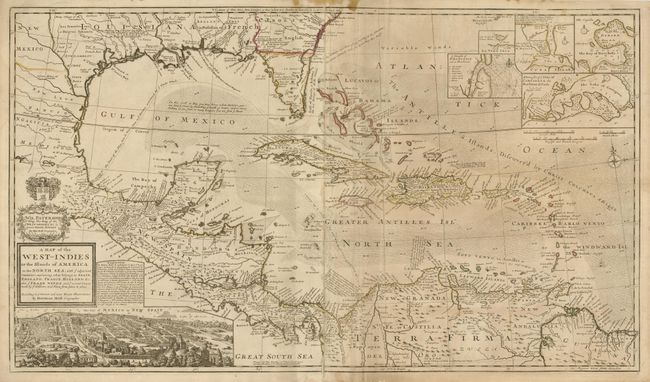
“A Map of the West-Indies or the Islands of America in the North Sea; with ye adjacent Countries; explaining what belongs to Spain, England, France, Holland &c. Also ye Trade Winds, and ye several Tracts made by ye Galeons and Flota from Place to Place”
Map Maker:
Herman Moll
This large and incredible chart is filled with so ... (full text available to subscribers)
| Item Detail |
| |
| |
MapMaker: |
Herman Moll
|
|
| |
| |
Subject: |
Gulf of Mexico and Caribbean |
|
| |
Period/Size: |
1720 / 23.0" x 40.0" (58.5 x 101.6 cm)
|
|
| |
Color: |
Black & White
|
|
| |
Condition: |
(B) Original outline color that is slightly faded. There is a stain in the top margin that just enters the map border and some minor abrasions along the centerfold. There are some old paper repairs on the bottom and top fold repairing a fold separation (condition help) |
|
| |
Source: |
|
|
| |
References: |
|
|
| |
|
|
| Sales Information |
| |
| |
Price: |
|
|
| |
| |
Offered by: |
Old World Auctions |
|
| |
Catalog: |
Auction No. 131 - Antique Maps, Charts, Atlases & Globes (682) |
|
| |
Lot/Item #: |
409 |
|
| |
| |
Date: |
02/2010
|
|
| |
| |
|
Antique Maps - Valuation and Pricing, Descriptions, Resources |
|
Home |
Information |
Search |
Register |
Contact Us |
Site Map
Americana Exchange, Inc. © 1999 - 2024 Americana Exchange, Inc.. All rights reserved.
OldMaps.com, the OldMaps.com logo and
AMPR are service marks or registered service marks of Americana Exchange, Inc..
|